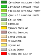
The University of Maryland Department of Geography produced this global land cover classification in 1998. Imagery acquired between 1981 and 1994 from the AVHRR satellites have been analyzed and digitally processed at the University's Global Land Cover Facility (GLCF) to distinguish fourteen separate land cover classes.
The research at GLCF focuses on determining land cover and land cover change around the world. Land cover is the discernible vegetation, geologic, hydrologic or anthropogenic features on the planet's land surface. These features, including forests, urban area, croplands and sand dunes, can be measured and categorized using satellite imagery. Land cover change is obtained by comparing one area with two images taken at different dates.
Further Description of the Land Cover Classification
The AVHRR satellite instrument consists of an array of sensors that record (as digital numbers) the amount of visible and infrared radiation reflected and (or) emitted from the Earth's surface. This provides images of the Earth's surface showing elements that cannot normally be viewed with the human eye. There are five sensors or "channels" on board each AVHRR satellite, each designed to record information from a different part of the electromagnetic spectrum.
The highest ground resolution that can be obtained from the AVHRR is 1.1 kilometer. This smallest recorded unit is called a pixel. AVHRR data have been collected continuously since 1981.The AVHRR sensor is also a useful tool for monitoring vegetation, land cover, and climate, and enables scientists to observe how these three elements interact. AVHRR data can be used to assess the quantity and vigor (photosynthesis activity) of vegetation through a measure of "greenness", referred to as the vegetation index or the Normalized-Difference Vegetation Index (NDVI). Using AVHRR, scientists monitor the growing season of crops - which can change with variations in regional climates - and can provide potentially life saving information to developing countries that heavily rely on an abundant and reliable harvest. From AVHRR data it is relatively easy to identify green vegetation and non-vegetated features such as water, barren land, ice, snow, and clouds.
More about the AVHRR instrumentation
Credit: University of Maryland, Global Land Cover Facility